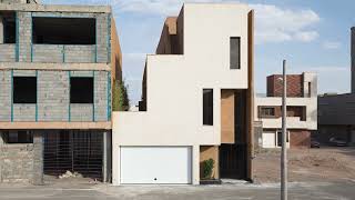
Renovation and Conversion of a Residential Building, Kermanshah. Peyman Amiri Paryan. This project is a residential building with two floors and a limited area. Based on need, one floor was renovated and its function changed within a short time and with a limited budget. The main idea was to replace the deteriorated facade of the building and convert the second floor from residential to an architecture office. The architectural concept was to create a white box with a minimal composition amid the mass of characterless and chaotic surrounding buildings. Client: Hamideh Amiri. Area: 70 square meters.
Architecture in Boshruyeh. Zohreh Bozorgnia. The county of Boshruyeh, located in the northwest of South Khorasan Province, was considered one of the districts of Ferdows County until November 2008, when it was elevated to a full county. Its geographic position is 33 degrees and 31 minutes north latitude and 57 degrees and 59 minutes east longitude, at an elevation of approximately 880 meters above sea level. According to the 2006 census, its population is 23,045, of whom 9,267 live in villages and 13,778 in Boshruyeh proper. Boshruyeh lies on the road from Tabas to Ferdows and serves as the gateway from Yazd Province to South Khorasan Province. The name Boshruyeh derives from "bosh," meaning dryland farming, or according to another account, from the name of a plant that grew in the region, and "ruyeh," meaning a place of growth. In the western part of the county lies the modestly elevated Shotori (or Shotoran) mountain range, which separates Boshruyeh from Tabas and the Lut Desert from the Salt Desert. The northern section extends to the Bajestan Desert (Salt Desert), spanning more than 250,000 hectares. Sand dunes are also visible to the east of the region. The area has a dry, desert climate, with maximum temperatures reaching 47 degrees Celsius and minimum temperatures dropping to minus 12 degrees Celsius. The northern villages are warmer, while the western villages, owing to their proximity to the Shotori mountain range, enjoy a more moderate climate. The region has no permanent rivers, and after seasonal rains, water flows through several seasonal rivers named Qaleh Vaghi, Risu, Fathabad, Kal-e Asfak, and Kal-e Shur. The area is covered with drought-resistant plant species such as tamarisk and saxaul, as well as medicinal plants including tragacanth, black cumin, and plantain. In the Shotori Mountains, there are also forest trees such as fig, mountain pistachio, mountain almond, and walnut. History and Historic Fabric. Not much documentation exists about Boshruyeh's historical background. Naser Khosrow Qobadiani mentioned the Jaameh Mosque of Boshruyeh in his travelogue, but did not name Boshruyeh itself. The Great Islamic Encyclopedia (Volume 12, page 188) states: "Boshruyeh is not very old, and approximately 400 years have passed since its establishment. Mir Mohammad Khan Arab, governor of Tabas (around 1200 AH), and his brother Mir Hassan Khan built a rampart around Boshruyeh. Colonel C.M. MacGregor, passing through this region in the 13th century AH, approximately 120 years ago, says: Boshruyeh is in fact a large village situated in the heart of a plain, surrounded by a wall... encompassing an area of 400 by 500 yards, with the longer side facing north. It has four gates, one on each side, and in the northwestern corner lies the citadel or fortress." He drew a simple plan of Boshruyeh's old fabric, including its gates, towers, rampart, and citadel, in his book. The area of this large fortress was approximately 16.7 hectares. The historic fabric of Boshruyeh is one of the rare intact fabrics whose architectural and urban features have remained since the Safavid period. This fabric had a perimeter wall and rampart, and of its presumably twelve towers, five remain. In the 1956 map, the city's perimeter wall and rampart are clearly visible (only the eastern section is somewhat indistinct). The shape of this map is trapezoidal, and two main axes pass through it: the north-south axis leading from the north to the village of Asfak and from the south to the Ferdows road, and the east-west axis running from the east to Kal-e Shur and from the west toward the village of Ragheh. The intersection of these two axes was the city's main square, with the bazaar located south of the square. The shape of the square underwent fundamental changes after the opening of streets during the Pahlavi era and the construction of a roundabout at its center after the revolution. The center of the Miyan Deh neighborhood, with its square and surrounding public buildings, has been preserved in its original form. The presence of the city's most important buildings—including the Jaameh Mosque, the theological school, the water reservoir, and the Haj Ali Ashraf Hosseiniyeh—around the Miyan Deh square indicates that this was an important and bustling central square in Boshruyeh. Neighborhood centers typically consist of a bathhouse, mosque, tekiyeh, water reservoir, and bazaars situated along a main road, but in Boshruyeh the number of bathhouses and water reservoirs far exceeds the number of neighborhoods. Map of elements of the old fabric of Boshruyeh.
The passages crossing through the center of the Miyan Deh neighborhood were called Miyan Deh Alley and Soltani Alley. South of the Miyan Deh neighborhood runs Bagh-e Melli and Hooshmand Alley, which begins at the municipality square and leads to the village of Ragheh. Along this route, numerous public buildings can be seen, including the Abdolsamad water reservoir, a mosque, a bathhouse, and another water reservoir. The center of the Payin Deh neighborhood was likely aligned with this axis. To the east, Hammam Alley passes through the eastern edge of the old fabric, where two bathhouses and a water reservoir are located, and to the west of it lie another bathhouse and water reservoir, so close together that they cannot be considered the centers of two different neighborhoods. This map clearly shows the density of the urban fabric, the presence of small courtyards at the center of houses, and the introverted nature of residential units. Courtyard areas in newer fabrics—some of which are located to the east, north, south, and west of the rampart and perimeter wall—gradually became somewhat larger, eventually leading to the placement of the courtyard on the southern side of the lot. The city cemetery was located south of the rampart, with a water reservoir adjacent to it. Winding alleys, adobe facades, domed roofs, varied one-sided and four-sided wind catchers and light wells, clay, plaster, and brick ornamentations, and inward-facing architecture are among the characteristics of Boshruyeh's historic fabric, which fortunately have not suffered much damage. Existing towers. Alleys of the old fabric.
Historic Buildings and Architecture of Boshruyeh. Ghaleh Dokhtar and the Mills: The oldest building in the county of Boshruyeh is Ghaleh Dokhtar to its west, attributed by some accounts to the Sassanid period and by others to the Ismaili period. This structure was built atop a mountain summit using mud brick and clay. The fortress contains sections such as large halls and spacious rooms, circular watchtowers, and a water reservoir. Directly opposite the fortress lies an ancient qanat whose course runs from the village of Ragheh toward Boshruyeh, with Ghaleh Dokhtar situated along its axis. Along the qanat's course, by one account seven and by another five water mills existed, likely dating to the Safavid period and approximately 400 years old. Their interior spaces are entirely similar to the windmills of Khvansharf (near Nehbandan) and Khaf and Nashtifan (in North Khorasan), differing only in their operational method and driving force. Beside each mill is a covered space containing an oven. The reason for these ovens was to allow those who brought wheat from afar for milling to bake bread while waiting for their flour. Around the mills stand ancient mulberry trees whose trunk grooves attest to their age and that of the mills. The mills are built of mud brick and clay with domed vaults. At present, only one of these mills remains operational. Water mill. A subterranean water canal (qanat). An old mulberry tree. A water mill. Ghaleh Dokhtar.
Historic Sarnav Bridges (Aqueduct Bridges): These bridges, which maintain the flow of water between two sides of a qanat, are among the fascinating water-related architectural works. The smaller bridge is attributed to the Sassanid period and the larger one to the Seljuk period. Hogand Mausoleum: Approximately 12 kilometers west of Boshruyeh, on the mountain slope, lies a pilgrimage complex known as the Mausoleum of Imam Zadeh Mohammad ibn Asghar Hogand, likely the burial site of one of the descendants of Musa ibn Ja'far.
Miyan Deh Jaameh Mosque: This mosque, located in the northeast of Miyan Deh Square, is a brick structure dating to the Safavid period. It has a large and lofty iwan surrounded by a portico with 14 arches. The main mihrab is at the end of the large iwan, and another mihrab is in a portico near the mosque entrance. The mosque has no minaret or gol-dasteh; only a short tower is visible on the roof of the iwan, more resembling a wind catcher, from which the call to prayer is broadcast. The courtyard floor is also paved with brick. Theological School: The theological school, or Madrasa-ye Talabe, is also a brick building located south of Miyan Deh Square, facing the Jaameh Mosque. This school has two iwans,
one for winter and one for summer, surrounded by chambers for housing seminary students. The facades of the chambers and one of the iwans are of plaster. The summer iwan facade is of brick, with its brick ornamentation in the alternating header-stretcher pattern. This building was constructed by Haj Abdolghani Hejri Boshravi in the year 1130 AH. Miyan Deh Water Reservoir: The construction date of the Miyan Deh water reservoir, or pool reservoir, is 967 AH. This brick structure is located east of Miyan Deh Square, with its iwan facing the square. Residents drew water from it in the pool method, using a bucket and rope. During the Qajar period, steps and a pashir (a water-drawing platform) were added to provide new access from behind. The iwan of this water reservoir features raised diamond-shaped brick ornamentations. Haj Ali Ashraf Hosseiniyeh: This hosseiniyeh, built in 1116 AH on the west side of Miyan Deh Square, has two iwans—one for summer and one for winter—with two-story porticoes around them, the ground floor designated for men and the upper floor for women. This building was constructed from the outset as a hosseiniyeh, and its plan resembles those of the hosseiniyehs of Birjand. Two other hosseiniyehs named Mo'ayyal and Robati also exist in Boshruyeh, likely dating to the Safavid period. The endowment of private houses for religious purposes has been common in Boshruyeh as in other parts of
Iran. Among them is Saray-e Serkeh, endowed for the recitation of mourning ceremonies for Imam Hossein. The Asfak Caravanserai, the Bibi Najmeh Khatun shrine, the Ragheh Jaameh Mosque, and several military fortresses are among the other historic buildings of this city. Residential Architecture. Here, two examples of houses in Boshruyeh have been examined. The Asadi Moghaddam House, or the city's private museum, has been described in detail in the article "Dasht-e Kavir" in Memar Magazine issue 53, which we will not repeat here. The Panahi House is another example featuring an octagonal courtyard, very similar to the Asadi House.
The only unique example of a Persian garden in Boshruyeh is Bagh-e Khan, of which we have limited ourselves to showing images. On the four sides of this large garden stand buildings, and spaces such as a pool house with an octagonal pool and a kolah-farangi (belvedere pavilion) with beautiful plaster ornamentations atop it, a wind-catcher room, summer and winter iwans, a basement cellar, a kitchen, and numerous rooms remain from this estate. Mostofi House: This house (national registry number 11920) is located on Molla Abdollah Tuni Boshravi Street and Mostofi Alley, and is among the aristocratic buildings constructed during the Qajar period. Its architectural style, beautiful wind catchers, an adjacent sabat (covered passage), and plaster and brick ornamentations are among its prominent features. The overall plan of the estate is rectangular. The entrance is situated in the middle of the western side, connected to the courtyard or monsara through a corridor. In the center of the courtyard lies a large rectangular pool, flanked on both sides by two rectangular garden beds. The courtyard floor is paved with brick. A lofty, two-story winter iwan with four round columns is on the northern side, and an octagonal pool house with a small circular pool at its center lies behind the main building. This structure is covered with a beautiful kolah-farangi and features artistic rasmi-bandi (geometric plaster pattern) ornamentations. The wind-catcher room, with three wind catchers above it—the central one square and two-sided, and the two flanking ones octagonal and four-sided—is located behind it. The other rooms, kitchen, bakehouse, and lavatories are built on the eastern and western sides. The building materials used are mud brick and clay. The stairs and the one-meter-high dado of the building are made of brick, laid in full stretcher or header-stretcher bond. Mostofi House facade. Roof lights. Sabat adjacent to Mostofi House. Wind catcher.