A visit to Bam citadel is one of the deepest, most poetical and exciting experiences of those who have visited this mud-brick city. It is the experience of a time in the past, with no sign of the present time. At sunset, when the sky of the desert would become red and a red light would cast on the mud-straw walls changing the atmosphere, nothing would prevent you from feeling the current of life in one hundred, or even two thousand years ago in this mud-brick houses. In such a moment, you would see all the city inhabitants of the past two thousand years in the alleys, in the tower and ramparts, in the houses and mosques and you would wonder that as long as these structures exist they are not going to die.
The devastation of the citadel is not just the destruction of mud-brick walls; it is the extermination of all those who had continued to live there for thousands of years. If more than thirty thousand people lost their lives in the annihilation of Bam, hundreds of thousands more laid down their lives by the destruction of the citadel. However, one could still hope to save some lives. Any remaining wall, or one that could be recovered from the debris, can rescue hundreds of historical lives.
Description of the City
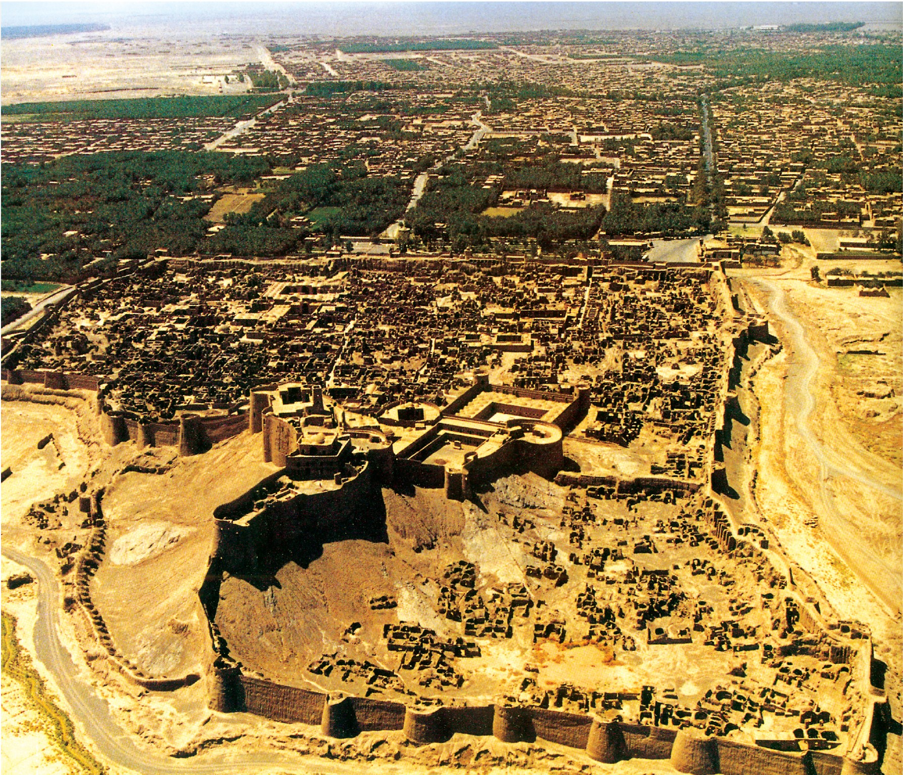
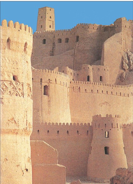
Bam citadel is a city which two thousand metres of rampart — four to thirteen metres high — and a moat about two metres deep and ten to fifteen metres wide turned into an impregnable fortress. (However hard I tried, I could not bring myself to use the past tense in describing the citadel of Bam — which today no longer really exists.) As the traveller Pottinger, who saw Bam in 1810, said: "The fortifications of Bam cannot now be compared to those of any most strongly fortified city. These fortifications consist of an elevated site, today comprising a high, thick mud wall and a deep, dry moat." This rampart is completed by forty-eight towers. The citadel of Bam covers thirteen hectares — twenty if one counts the moat — and is composed of two parts: the larger commoners' quarter (āmma-neshīn) and the smaller, governor's quarter (hākem-neshīn), which dominates the entire city. The commoners' quarter, less subject to later restoration, has seven neighbourhoods; one can tell from the shape and size of the houses that these neighbourhoods had certain guild and class characteristics, the houses around the Friday Mosque being grander and those of the so-called "Kenār-mahalleh" being more modest.
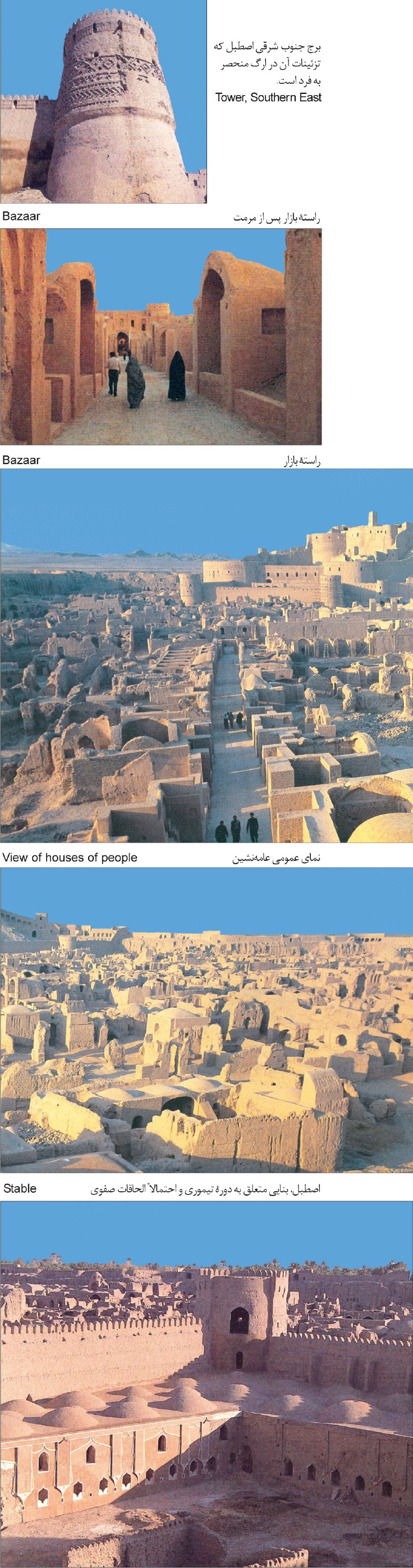
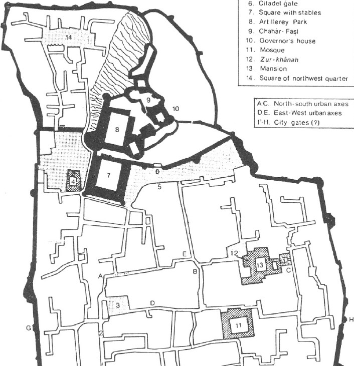
Past the entrance gate of the commoners' quarter — flanked by two semicircular towers — the city's most important and widest street runs north toward the governor's quarter. The bazaar street, about a hundred and ten metres long with some fifty cells and a chahār-sūq (crossing-shops) in the middle, runs along this axis. The Tekyeh (religious assembly square) lies at the intersection of this street with the street on which the Friday Mosque stands; the city's river also crosses here. This second street, with the Friday Mosque, the Mirzā Naʿim madrasa, the bath, the zūr-khāneh (traditional gymnasium), the caravanserai and other elements of urban life along it, is the city's second most important axis. The Friday Mosque, one of the most important mud-brick mosques in the world and one of the oldest buildings in the city, together with the Mirzā Naʿim madrasa, lend this axis great importance. Other urban features — bath, zūr-khāneh, caravanserai etc. — all lie in the commoners' quarter.
The main axis continues with a slight bend and a steep slope to the entrance gate of the governor's quarter, set on the second rampart. In front of this gate is an open space which, according to Professor Heinz Gaube, may have been the place where punishments were carried out — those held in honour or in disgrace by the ruler being publicly displayed here.
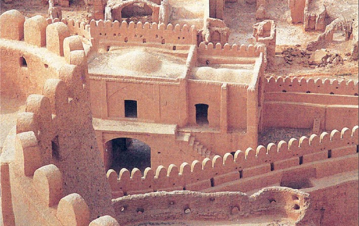
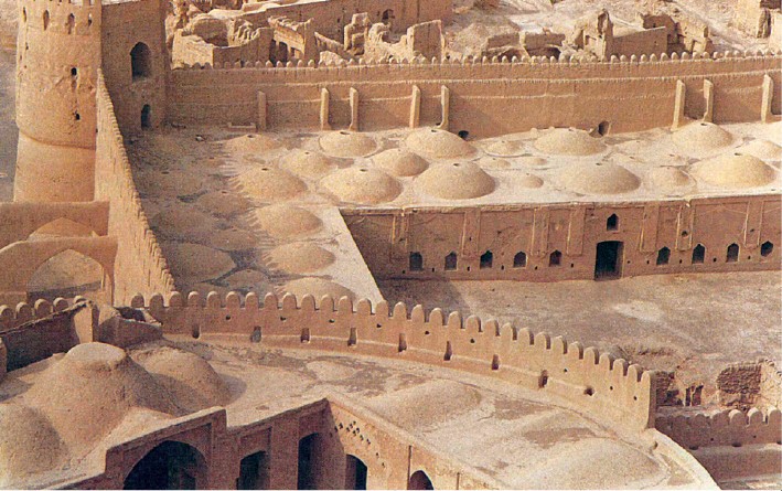
Beyond this gate, an east-west passage leads to the stable. The governor's stable, sixty by seventy metres, is one of the largest and most splendid buildings in the whole complex. Behind the stable lies the third rampart, on which the gate known as Kat-Karm (or "Kad-e Karm" — "house of the worm") sits — a gate today walled up. Beside this gate, a staircase leads onto the rampart wall, from which one can reach the governor's residence. The story of the Kat-Karm gate and of the Castle of Haftvād is told at length in the Kārnāmag of Ardashīr-i Bābakān and in Ferdowsī's Shāhnāma. Within the third rampart are the barracks, somewhat smaller than the stable, the commander's house and other military installations. The traveller Sykes, who visited Bam in 1875 and was received by the ruler, said: "In the courtyard of the barracks I saw a few muzzle-loading field guns mounted on equipped carriages. The date of one of them which I remember was 1254 AH (1838 AD)."
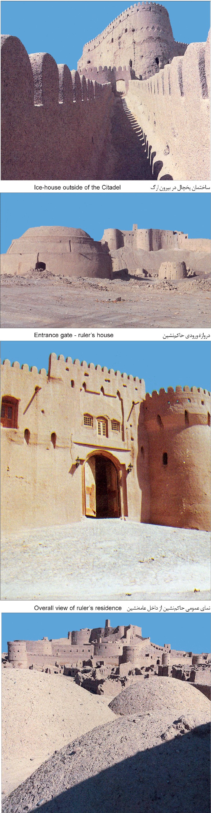
Below the commander's house is the prison of the citadel. Passing the commander's house and following a steep, partly covered passage, one reaches the governor's complex (qalʿa-ye hākem), which stands on the highest part of the citadel, some sixty metres above the entrance. This complex includes the governor's house, his bath, the chahār-fasl ("Four-Seasons") pavilion and the watchtower. The Four-Seasons pavilion, built on the chahār-saffeh ("four-vault") pattern, has four iwāns opening to the four cardinal points. It commands the finest views of the citadel — both inwards and outwards — and during the summer heat, with the constant breeze passing through it, would have been a pleasant place to live. The rooms of the governor's house, despite the very small courtyard, are decorated in a manner befitting the rank of their owner. Pottinger, describing the governor's house, says: "The floors of the rooms were covered with Persian carpets, and felt rugs for sitting were laid out around the walls. The rooms were painted white, with gold-leaf plaster ornaments."
The governor's house had its own bath. The last and tallest part of the citadel is the watchtower (borj-e dīde-bānī). This tower, originally taller and probably round, was destroyed during the Qajar period and rebuilt with a square plan and four storeys.
History and Origins
The historic city of Bam was made up, in fact, of a series of nested castles. The word arg, in its proper sense, means a small castle built within another castle. As Professor Heinz Gaube has remarked: in Muqaddasī, qalʿa and hisn are clearly distinguished from one another. We must translate qalʿa as "citadel"; then hisn must be something other than arg, and is probably to be understood as the city enclosure-wall. But given the dictionary meaning of hisn — a strong fortified high place — the use of the two near-synonyms seems to allude to the citadel's nested character. In any case, the word arg appears to refer only to the governor's quarter, the term having later been extended to the whole complex. The fact that the complex sits on a mound at least five metres above ground level may be due to successive destruction and rebuilding of the city on its own ruins; but the citadel's natural sandstone hill, with its gentle slopes towards the south, suggests that the moat may also have been deliberately cut. The urban fabric of the citadel, like its functioning, is divided into two distinct parts: the commoners' quarter, which by analogy with the traditional Iranian city can be called the shārestān, and the arg proper, which can be called the kohan-dezh.
The street network in the commoners' quarter is a roughly grid-like arrangement of east-west and north-south streets, organically broken into many bends. The most remarkable feature is that there is only a single gate, in the south of the citadel, and a small secondary entrance two hundred metres away. For this reason all of the lesser streets end in cul-de-sacs, and only the main street — along which runs the bazaar — leads to the governor's quarter. The presence of the bazaar and of the Hosseiniyeh along this route is natural. The remoteness of the Friday Mosque from the bazaar is somewhat unusual; however, the proximity of the Friday Mosque and the Mirzā Naʿim madrasa on one side, and of the bath on the other side of the street where the Friday Mosque stands, indicates the importance of this axis. It should be noted that this same street also carried the city watercourse. In the north-west corner of the complex stands a quarter, separated from the rest by what appears to be the old city wall. This quarter, called Kenār-mahalleh or Gholām-mahalleh, was inhabited by the poor and has small, modest houses. Its peculiar feature is a large square in the middle, perhaps the largest open space inside the citadel.
A wall of the governor's quarter survives, the steep slope of which has prevented anything from being built on it. The governor's quarter has a different urban fabric: there, the topography of the steep slope determines the layout. The alleys and citadel walls follow the contour lines, and the buildings are arranged in a stepped manner along the slope, so that the courtyard of each house is also higher than the roof of the house below. One of the most beautiful aspects of the complex is this morphological contrast between the governor's quarter and the commoners' quarter.
Water Supply System
Water reached the complex by two routes. The first was via a channel called the Nahr-e Shahr, which came from a qanat west of the citadel and entered the city via a shotor-galū (literally "camel-neck") culvert, the entry point of which lay close to the public bath. From there the water was carried by clay-pipe (tonbūsheh) to various points — including the cistern of the stable — and exited the eastern side of the city. The second method was by wells. Although Bam lies on the southern edge of the Lut desert, the Jebāl-e Bārez range, some 2,700 metres high, makes the underground aquifer of Bam unusually rich. For this reason much of the water of the governor's quarter, which could not draw its water from the channel, was supplied by wells of excellent quality. Famous wells of the complex include the Sāheb-al-Zamān well at the south-east corner of the mosque, the barracks well at the south-east corner of the barracks (28 gaz deep) and the governor's house well, beside the governor's bath (about 40 gaz deep). The Posht-rūd, a watercourse to the north of the city, may also have fed the moat.
Myth and Antiquity
Most of the texts that deal with the history of Bam refer to the city, in the legend of Bahman, son of Esfandiyār, who avenged his father by killing Farāmarz son of Rostam, as the city's founder. The river Gaz-Bahman, in Rīgān — one of the regions near Bam — preserves a trace of this legend. Bahman bore the epithet "long-handed", and on this account historians have identified him with Artaxerxes Longimanus, the Achaemenid king. The shape of the gates and other architectural details — to which more specialist articles can be referred — reinforce this hypothesis. Of course the Achaemenids, given the imperial character of their dynasty, also borrowed from the architecture of the lands they conquered. The Assyrians and Elamites, who were under Achaemenid rule, had cities whose external appearance closely resembled that of the citadel of Bam. The reliefs on the famous bronze beaker of Kidin-Hutran, an Elamite work dating from about 1335 BC, show a fortified city whose architectural form bears a striking resemblance to Bam — and even one of the towers of the second rampart resembles, astonishingly, the towers on this beaker.
It is said that, in Ferdowsī's Shāhnāma and the Kārnāmag of Ardashīr-i Bābakān, mention is made of an event today commemorated by a walled-up gate of the citadel. Some have even derived the name "Bam" from the cracking sound of the worm (kerm) of Haftvād, killed by Ardashīr-i Bābakān when he poured molten lead down its throat. On this theory, the construction of the citadel goes back to the Sassanid period — but the discovery of Arsacid coins on the site suggests that the mud-brick complex of Bam goes back at least to the Parthian era.
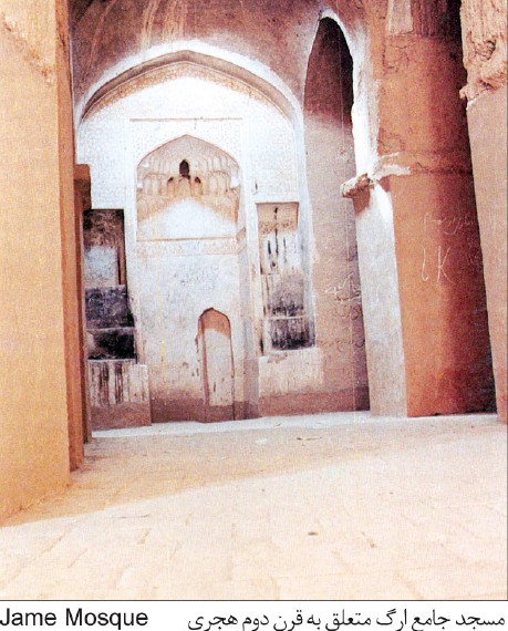
The mosque of Hazrat Rasūl is the most important monument bearing witness to the prosperity of Bam in the early years of the Arab conquest of Iran; its remains still stand outside the citadel today. It was built in 31 AH by ʿAbdallāh ibn ʿĀmer, the Arab governor of Kermān. In 562 AH, after the death of Toghrol Shah Saljūqī, the Ghuzz attacked Bam during the weakness of the Saljūq dynasty and pillaged it. Yet once again, under the Qarā-Khitāy, peace and prosperity returned to Bam, and this dynasty even kept Bam safe from the Mongol calamity. Amir Mobārez-al-Dīn Mohammad-ibn Mozaffar captured the citadel in 740 AH, putting an end to Qarā-Khitāy rule.
Under Timur, Bam was pillaged and destroyed, but traces of construction from his time can still be found in the citadel. The long peace of Safavid times brought substantial building activity to Bam, and this calm continued under the Afsharids (Nāder Shah), the Zand dynasty and even, in part, into the early Qajar period. Bam preserves abundant evidence of construction from all these periods. The last major event in the history of Bam was the residence of Jahāngir-Khān Sistānī and the sons of Mohammad-Hossein-Khān Sistānī. Later, under Mohammad Shah Qajar, Bam became the seat of Āqā-Khān-i Mahallātī, whose battles with the governor of Kermān caused some damage to the buildings.
In the mid-thirteenth century AH — toward the end of the Qajar period — with the prosperity of the new town outside the citadel and the gradual abandonment of the citadel by its inhabitants, the citadel was used as a military fort for the garrison. Under the early Pahlavī dynasty it then housed the gendarmerie. Between 1320 and 1346 SH, before the citadel came under the protection of the National Organisation for the Conservation of Ancient Monuments, the citadel was deserted, and perhaps the most severe damage to the citadel dates from these very years: it is said that in this period people even tore down the buildings to use the earth as fertiliser in their fields.
And finally, with the earthquake of 6 Dey 1382 (December 26, 2003), the citadel of Bam was driven to the brink of complete annihilation — a destruction that has deeply affected all cultural institutions, inside and outside Iran, and which is why no one has hesitated about its restoration. But in what does this value of the citadel of Bam consist?
Why the Citadel Matters
Studies of historic urban fabrics — undertaken precisely to bring to light the obscure pages of the history of Iranian architecture and urbanism — are under way in most Iranian cities. But the citadel of Bam, as a complete city in which no modernisation had taken place, has come down to us, in terms of integrity and unity, like a museum object — a unique example in which every component of the Islamic city, gate, bazaar, Friday mosque, Tekyeh and so on, can still be identified. Mud-brick is still one of the materials used in building, not only in dry climates but even in the heart of Europe. Today, with attention to the environment, to the recyclability of materials and to energy conservation, mud-brick has again become the object of worldwide interest. Researchers and conservators of historic buildings are studying mud-brick with renewed seriousness. The citadel of Bam, built entirely of mud-brick from the various periods between pre-Islamic times and the Qajars, allowed the full possibilities of mud-brick to be studied: as a structural element, as an ornamental element, as a prefabricated material able to generate soft, continuous forms, as a unifying element binding all the components of the city together, as a material in harmony with the climate, and with many other possibilities we do not yet know about.
In the history of urban civilisation in Iran, many questions remain unanswered. Although researchers have made some allusions to cities composed of kohan-dezh, shārestān and rabaz, and many cities have been interpreted within this scheme, it seems that the city as a form of civilisation — and not as a strictly military fortification — has not received the attention it deserves. There is a fundamental difference between a walled city and a castle. A castle is usually built on a height, relying on a natural feature — a mountain, a river — to defend itself; a city, on the other hand, relies for its defence on its rampart alone. A city is built upon roads or at their crossings, and for that reason has many gates; while a castle, in most cases, has only one. In the historical process of sedentary life, the castle gradually lost its function, giving way to the city. The impossibility of expanding this form of settlement was its principal limit. With the growth of population, the city became the efficient, responsive model. The wars of Hasan Sabbāh and of the Ismāʿīlī fortresses against the central government were in fact wars against the city. But the citadel of Bam, for various reasons, was not a city in the developed sense — it was, rather, the last great example of qalʿa-neshīnī (life in a castle-town), which preserved its life until very recently. While Elamite, Median and Achaemenid cities were all in some sense forms of qalʿa-neshīnī (and even the surviving Parthian cities still carry the word "castle" in their names, such as Qalʿa-ye Paras), Bam, by adding habitational features to its military character, remained limited to the castle form.
It is, then, my opinion that one should not take too seriously the small gate two hundred metres from the main gate, and one should accept that Bam, alongside its principal road, had only one gate and was indeed a fortress (qalʿa). Even in those periods when, on account of regional prosperity, a great enclosure-wall — called Shahr-bast — was built, additional gates were placed in it of necessity. For many reasons, this outer part of the city never took firm root before the late Qajar period, and on each occasion the outer town was destroyed and the population again preferred to live within the citadel. The citadel of Bam is therefore, in this sense — as the last and most complete fortified town of its kind — a museum of the patterns of Iranian architecture and of various periods of construction. Within it can be found the iwān-shabestān mosque, the covered bazaar, the Tekyeh, the caravanserai, the introverted house in its most complex and its simplest forms, the kūshk house, the chahār-saffeh, the stable, the barracks, the bath and so on. The historic walls of the citadel and some of the foundations of the houses date at least to the Parthian period and, more generally, to the pre-Islamic era. In Professor Pope's opinion, the Friday Mosque belongs to the second century AH and to the Saffarid period; the mosque also bears traces of the Saljūq, Safavid, Afsharid and Qajar periods. The stuccoed mihrāb of the mosque's shabestān carries the date 1164 AH, that is, the reign of Shāhrokh, one of Nāder Shāh's successors. The stable also belongs to the Saljūq period, and the zūr-khāneh too; the caravanserai is among the buildings of the Safavid period, and the governor's house, with some alterations belonging to the Zand period, also dates from the Safavid era. The Four-Seasons pavilion was built in the Zand period, while the Mirzā Naʿim madrasa, the watchtower and the Tekyeh were all built in the Qajar period. By careful excavation of the foundations of the buildings, it is likely that traces of pre-Islamic structures will also be found.
Finally, the citadel of Bam is an inexhaustible repertoire of forms which, quite apart from their function and date, are unique in their kind; and their volumetric compositions, from whatever angle, are perfect, of the highest beauty. In the citadel, repetition and variation produce together combinations of which we have little experience in our own life — and this is perhaps one of the secrets of the inexhaustible charm of Bam as a world of form.
After the Earthquake
Five kilometres from the city, one would not believe that anything had happened. Everything looks intact. The mud-brick houses have, at most, cracks on their walls. But as one enters the city, the closer one gets to its centre the stranger the scenes become — as if the city had been bombed. Many mud-brick houses and brick buildings with steel frames have collapsed. Among the survivors there are both mud-brick and steel-framed buildings. Some mud-brick vaults are not even cracked, while another mud-brick house alongside is reduced to walls less than half a metre high.
Although I have been to Bam several times before, the city is no longer familiar. Asking for directions, I find the street that leads to the citadel. It seems the epicentre of the earthquake was beneath the citadel itself. Very little remains of the entrance — in fact, nothing remains. Particularly because of the work of recovering the bodies of those buried beneath a hill of earth and rubble, even the two large, round shells of mud — once the towers flanking the entrance — are the only surviving sign of the gateway.
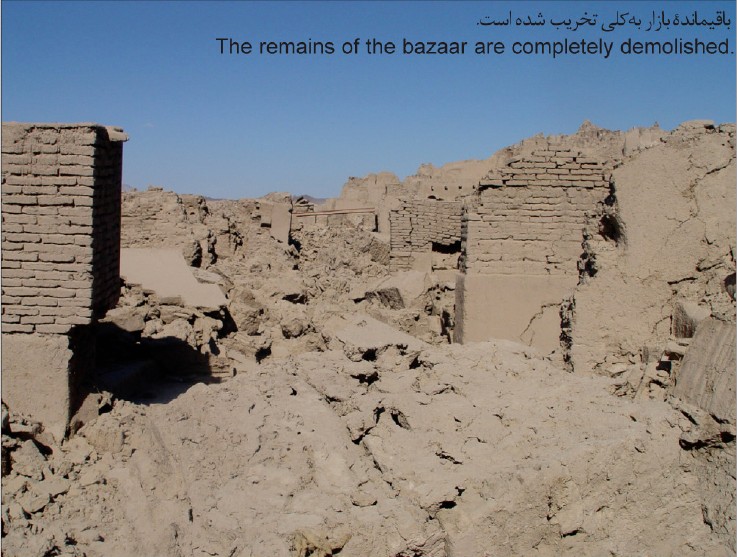
From a path resembling a mule-track, I climb onto the rampart, almost half of which has collapsed, exposing the chineh (rammed-mud) core. Bypassing the entrance, which is now impassable, I go around and stand facing the bazaar. I could not have recognised this hill of earth as the bazaar. The walls have all fallen. With difficulty I make out the chahār-sūq. Near the chahār-sūq, two cells with their wooden doors and windows have survived in an astonishing way, with at most a few cracks in their walls.
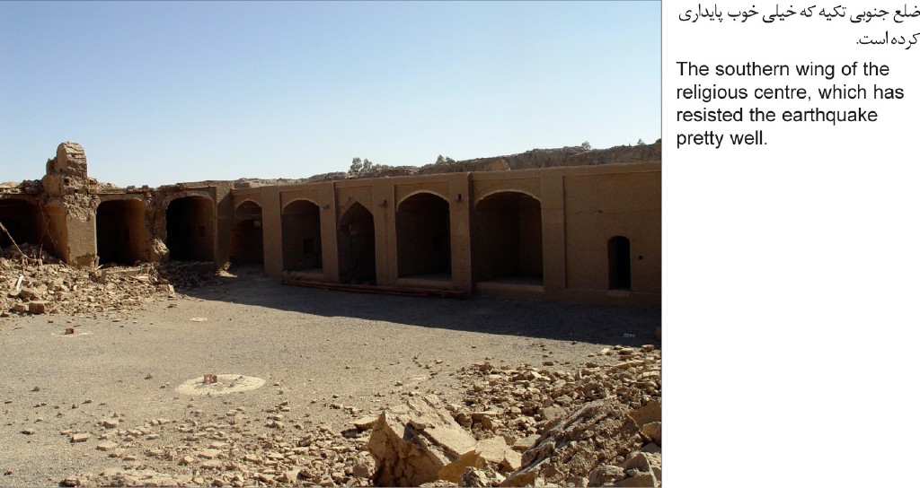
I reach the Tekyeh. Its open courtyard is the first place where the old paving can be seen. The Tekyeh's appearance gives some hope. The southern flank, despite some cracks, has not collapsed, while the western wing has also been demolished. I return to the main path. The caravanserai is unrecognisable.
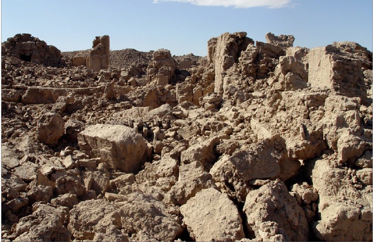
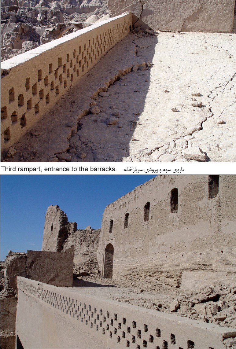
The second rampart and the tower whose ornamentation distinguished it from the others — the tower that resembled Elamite ones — have collapsed. The rampart beside the stable has been so crushed that it looks as if it had been blown up from beneath. From here one can enter the stable courtyard. The western face is destroyed by perhaps thirty percent and the northern by perhaps forty percent. Strangely, the cistern at the centre of the stable courtyard has not even cracked — as though the earthquake had spared this one point. I leave the stable by its northern gate. The alley leading west, towards the entrance of the governor's quarter, is intact, but the paving stones of the path have cracked. I move on. The lintel of the barracks gate is perfectly preserved. One cannot understand why some places have been completely destroyed while others have not even cracked.
I pass under two intact arches. Seeing the courtyard of the barracks makes me happy. The barracks may have suffered less than twenty percent damage. The northern and southern fronts are in better condition; the walls running east-west have endured better. Perhaps the direction of the earthquake explains this difference.
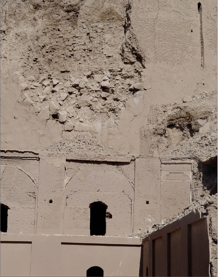
From the eastern side, I cross under the arch that connected the commander's house to the barracks, towards the commander's house. The eastern flank of the barracks has been damaged. Passing through the dālān (passageway) and the entrance of the commander's house — which is almost intact — I reach the vestibule, which is also in good condition; I mean that no weight seems to have fallen there. But on entering the courtyard of the commander's house I face an astonishing sight. Of the military commander's house almost nothing remains. Ninety-five percent destruction is the minimum reasonable estimate for the commander's house.
From the top of the ruins of this building, the third rampart is visible. The third rampart, unlike the second and fourth, is in better condition; even some of its merlons (kongereh) have survived in places. From beneath the fallen earth, the foundations of the towers of the fourth rampart can be seen. To climb to the governor's house over this avalanche of mud-brick and earth is no longer possible. Returning to the roof of the barracks, I try by the paved path of the western rampart to reach the Four-Seasons pavilion. Ten metres before, the path is blocked. But what can be seen of the governor's buildings, the watchtower and the Four-Seasons pavilion tells of an eighty to ninety percent destruction of the governor's house. The plastered northern wall is the most intact part of that fine building. Of the four storeys of the watchtower only one remains, and even that is heavily damaged. From where I stood, of the Four-Seasons pavilion only a plan less than a metre high could be seen. The governor's bath was not visible at all, but given that it lies beneath the governor's house, it may have remained better preserved. From here the Kenār-mahalleh can be seen — and since it did not contain a sound house even before, no great change is visible there.
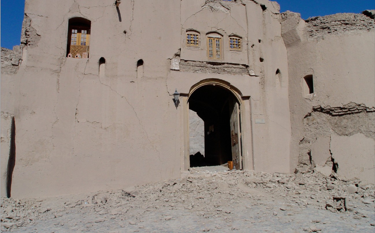
I returned downhill. Passing the destroyed eastern wall of the stable, I reached the gate of the governor's quarter. The gate is about ninety percent intact. From the gate of the governor's quarter I make my way to the Darvāzeh-ye Kat-Karm, which is astonishingly intact — as if Kat-Karm's "luck" had still been with it today. Returning from the gate of the governor's quarter, I head towards the Sābāt of the Jewish quarter. The Sābāt itself survives, but the recent restorations of the houses of the Jewish quarter have been destroyed, making it difficult to pass beneath the Sābāt. From the Tekyeh I move on towards the Friday Mosque. A few metres further the ruined walls block the paved path. Crossing over the ruins of the surrounding houses, I reach a fork: the signpost shows the Friday Mosque and the Mirzā Naʿim madrasa on one side, and the bazaar and the Tekyeh on the other — but the latter two no longer exist, or only small portions remain.
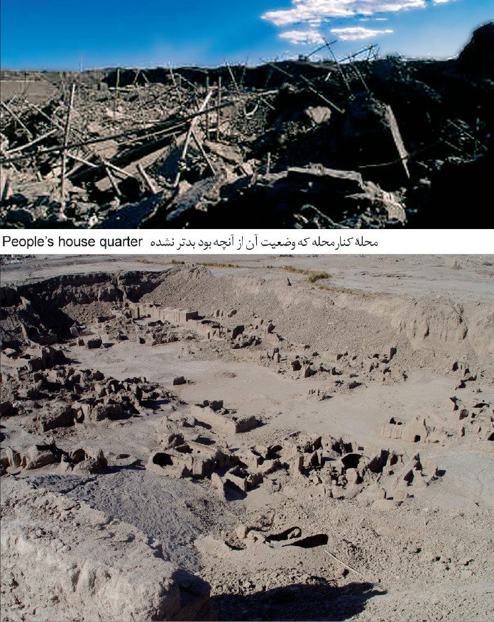
I continue along the alley towards the Friday Mosque. It is astonishing: except for the entrance door of the Friday Mosque, almost nothing of it remains, as if everything had been hurled into the sky and rained down around. The Friday Mosque — the oldest building in the complex and one of the very few surviving Saffarid monuments — no longer exists. If one counts the surviving entrance and the half-pillar at the site of the Sāheb-al-Zamān well, one can say 99.5 percent has been destroyed. The Mirzā Naʿim madrasa, facing the Friday Mosque, is in better condition. Aside from damage to one cell, the other cells stand. The northern flank is also in fair condition, but the bādgir (wind-tower) wing has been almost entirely destroyed: about ninety-five percent of the southern and western flanks are gone, and three sides of the bādgir have completely fallen. I go on towards the great house of the rich (khāneh-ye aʿyānī). A seventy percent destruction estimate is the most optimistic one. From the corner of the houses that had served as the office of the Cultural Heritage Organisation, the path becomes impassable.
Critical Observations on the Recent Restorations
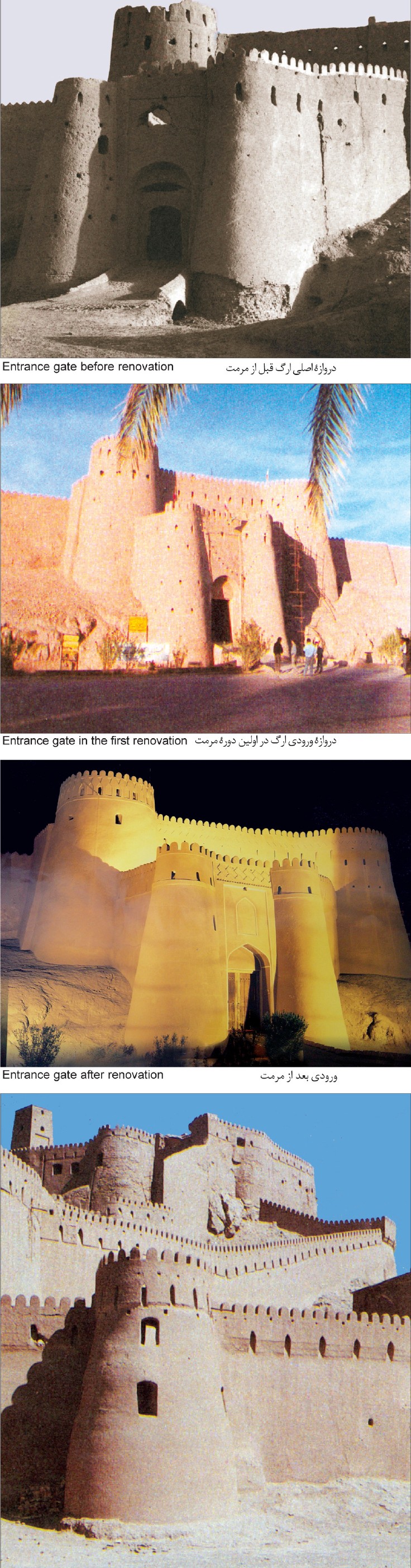
No proper drawings or plans of the restoration are now available. What has been done has continued the old technique; the opportunity offered by restoration for structural consolidation has not been taken. Major changes have been made in the shape of entrances and other openings. As an example one may compare images of the main gate before and after restoration: the segmental arch of the entrance has been turned into a pointed (jenāqī) arch, and on the upper part of the gate raised decorations have been added in kāhgel (mud-straw) that did not originally exist. The repetition of merlons (kongereh) along the top of every tower is questionable; many of the small openings on the towers have been blocked. The same treatment has been extended to other towers which originally had no such ornamentation at all. Another problem is that buildings from different periods have been treated in a uniform way, with the result that differences in execution — which surely existed in different periods — have been buried under a single layer of kāhgel and gypsum render, so that the entire citadel now appears to have been built at a single moment.
Those who, in the warp and weft of the mud-bricks of the citadel, have carried on a historic life, are waiting for our right decision.
1 "Kat-Karm" or "Kad-Karm" means "house of the worm".
2 This section is drawn from the writings of Professor Heinz Gaube.
3 According to Heinz Gaube, the citadel had two gates, in the east and west, though he gives no evidence for this conjecture.
4 This section is composed using articles by Heinz Gaube and Dr. Tayyāri. (Owing to lack of space, the references are not listed here, but are available in the office of the magazine.)
5 The illustrations are taken from written sources on the citadel.